Discovering Fort Worth on foot: An introduction
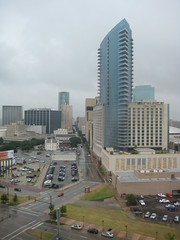
Andrew and I have begun taking walks around our neighborhood and the surrounding neighborhoods in downtown Fort Worth. Mostly, this has been for exercise, since we’ve noticed we’re not nearly as active as we were when we were in school. We’ve been doing this for several weeks now, and it’s proven to be a very interesting and educational experience. We’re discovering new places and learning how roads and neighborhoods connect in ways that would never be possible in a car, or even on a bicycle. Our approach to walking around downtown is actually pretty organic–we start at home, pick a general direction, and then wander along streets and trails until we decide to turn around and head home, usually taking a different path than we came. Sometimes we have a destination in mind–“let’s walk to TCC;” or “let’s walk to Montgomery Plaza;” or “let’s walk to Trinity Park.” Most times, however, we just pick a general direction and take the same approach I recall taking as a kid when my friends and I would explore our neighborhoods: “let’s see what’s over here!” This results in taking a lot of non-optimal paths between where we start and where we end up, but this sort of non-linear exploration has also resulted in some eye-opening revelations about Fort Worth’s city planning philosophy. I hope to make a series of posts about the things I learn and notice about Fort Worth itself, as well as some more general observations and thoughts about urban (re)development and city neighborhoods. There will be pictures, though probably mostly taken with my phone, since lugging around my camera on 8-10 mile urban hikes in 90+ degree heat is not my idea of a good time.
In which a little knowledge ruins everything and makes it more interesting…
If there’s one thing that simultaneously improves and completely ruins the experience of walking around in an urban area, it’s having any kind of background in city planning or urban policy. Some things you notice immediately, like how the interstate and freight rights-of-way create barriers between downtown neighborhoods, causing disparities in development. The Trinity River is another such barrier, albeit a natural one, so the types of separation and development issues it causes are significantly different than those created by a highway. Generally speaking, people would rather live next to a river than next to train tracks, and the area surrounding a river is usually more aesthetically pleasing than the area surrounding an urban highway. As a result, the areas near the river are usually a lot nicer than the areas near the interstate. Usually.
Other things are a little more subtle and require a little background information, like how downtown goes from being a pretty walkable, clean and modern urban area to being a sort of ghost town of urban blight and out-of-control housing speculation in just a couple of blocks. Some of the background is generalizable–many cities experienced population decline and blighting following World War II, as families moved to the suburbs. This trend continued until very recently, when suburban sprawl led to long commutes, which (among other things) led to demand for live-where-you-work-where-you-play urban revitalization. From another perspective, however, urban redevelopment happens the other way around–some event triggered it in a small area, and then people moved in, in part because it was now a nice place to live and in part because it shortened their commute. Word gets out about how awesome that is, and a domino effect of development and demand occurs.
In Atlanta, for example, the 1996 Summer Olympics resulted in HUGE public and private investments into revitalization of (mostly) Downtown and Midtown neighborhoods, which set off a development and infrastructure boom that continued for the better part of the next decade. You can still see echoes of that initial development push in Atlantic Station and in the Beltline Project. In Fort Worth, I’m told it was primarily a huge influx of private money into the development of Sundance Square that set off a revitalization boom in Downtown and surrounding neighborhoods. Another big revitalization push in Fort Worth comes from the Trinity River Vision project, a public-private partnership that advocates responsible development around the Trinity River and its tributaries in Fort Worth. (On a side note, their Wikipedia page is in terrible shape…I might make it a personal project to fix that.)
In which I talk a lot about Atlanta…
For someone who is walking around Fort Worth, I will probably talk a lot about Atlanta. I’ve already mentioned it once already. I lived in Atlanta for over seven years while I studied at Georgia Tech. I am very familiar with its politics, its history, its neighborhoods, and its various (re)development projects. Fort Worth is still pretty new to me, and part of this whole series is about my learning experience. Learning happens in context–you create analogies between what you already know and what you’re learning. One of the first things I noticed about Fort Worth when I moved here is how much it’s like Atlanta was about 10 or 15 years ago (from a development standpoint, at least). There are a lot of comparisons to be made.
Additionally, many of the people who read this blog are from Atlanta and have never been to Fort Worth. I want to give them some context. Likewise, I think the comparisons will show how a lot of planning philosophies are pretty generalizable.
In which I will probably talk a lot about ‘walkability’…
I’m a walker. Not a cyclist, not a driver. I walk. Sometimes I take rapid transit. (I’d probably take it more if there was a worthwhile rapid transit to take, but that’s another post.) One of the things I care most about is how easily and safely I can walk from Point A to Point B. My assessments of areas I explore almost always involve me uttering the word “walkable” at least a half-dozen times. What makes an area walkable? Sidewalks, for starters. That usually helps. But you can’t just lay down a strip of concrete next to a road and call it good. Making an area walkable also means making pedestrians feel safe. That means putting in lighting, creating some kind space or barrier between pedestrians and traffic, engineering intersections to make crossing easier, maintaining the sidewalk so that it’s not crumbling or uneven, and many other considerations. As gas prices and waist measurements both trend upward, making cities more pedestrian-friendly is of the utmost importance. Fort Worth has already done a lot to make the city more bicycle-friendly, and there is already an abundance of advocates for that. I want to be an advocate for a more walkable Fort Worth.
In which I post about random stuff…
As I mentioned, walking around a city gives a perspective on things that you don’t always get. The other day, I got a good, close-up look at the support structure of the Lancaster Avenue bridge. A couple weeks ago I discovered that it’s pretty easy to walk to Montgomery Plaza, but not so easy to get in or out of the development on foot. (More on that in a future post…) I have also learned that it is more comfortable for me to walk long distances in flip flops than in sneakers, that swans apparently sleep in trees, that there’s a rare and used book store on Throckmorton (that has weird hours so I haven’t checked it out yet), and that there’s a rope jungle gym in Burnett Park that’s really fun to climb.
So that’s what I’m doing this summer.


